
A rapidly growing trend in the Civil Engineering industry is the incorporation of Geo-Spatial information (GIS) as part of the engineering project development process. MG AEC Technology Partners (“MG”), in association with Esri and Autodesk, assist clients on much richer project development processes. MG’s Civil Engineering to GIS Service Package provide firms everything they need to set up a robust CAD to GIS program – and a much more informed engineering, design, and construction environment. These processes provide a deeper understanding of the actual project environment – in turn facilitating more intelligent project design and construction practices. Civil Engineers have used GIS data as part of their engineering planning and design processes for years. Until recently, GIS and CAD data were generally siloed, making it difficult to use data for both.
The recent cooperative partnership between Autodesk and Esri, respective leaders in the Engineering Design Technology field and the GIS field, has led to rapid growth towards bi-directional CAD and GIS data integration. This in turn is leading to enhanced methods of project planning, iteration, design, and analysis methods. We are also starting to see reduction in design and construction errors due to incomplete information from which critical decisions must be made. This CAD-to-GIS connection is also allowing for faster field data collection and more robust project communications between principal firms, stakeholders, regulatory agencies and the public.
There are many tips, tools, and techniques to help firms. Here are five that can strongly effect your firm’s project workflows.
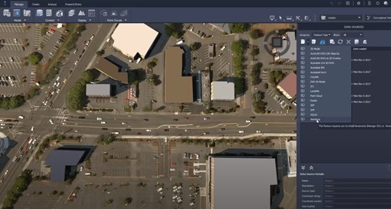
Civil Engineering firms are now able to tie together a wealth of ArcGIS based data with Civil 3D or Infraworks project files. The Connector, developed by Autodesk, is included on the toolbar with Civil 3D 2020.1 or Infraworks 2020 subscriptions moving forward. There is a great deal of bidirectional functionality available today, as well as, a healthy development roadmap for the Connector as ArcGIS and Autodesk geometry methods develop an increased common mutual language. Autodesk users wanting to compile and fully engage and edit the data flowing back and forth, will need a minimum of an Esri AEC Location and Design Collection to compile the desired project relevant ArcGIS map data. An ArcGIS Editor license is also needed for each designer needing to fully interact between the Civil 3D/Infraworks and ArcGIS data.
The following video supplies an overview of the Connector capabilities: Esri ArcGIS to Autodesk Civil 3D/Infraworks Connector
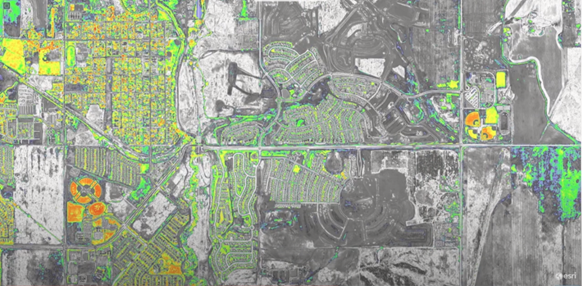
Autodesk Infraworks to ArcGIS Connected Maps and Building Images.
One of the first questions Civil Engineering firms ask regarding the advantages of incorporating GIS data into their project processes is, “Where and how do we find the maps and information we need for a project?” There are many sources of data, often at no charge. State and local government agencies along with federal agencies maintain well populated GIS portals. There are also a host of privately supported GIS portals.
The best place to start is Esri’s ArcGIS Living Atlas of the World. Esri maintains and makes available vast libraries of current GIS data for countless entities for the United States and the World . Esri curates and performs QA/QC to make sure materials are current, relevant, reliable, and up to proper access and use standards. There will be times, although rare, where Civil firms will need to locate sources apart from the Living Atlas. Having Esri point you in the right direction, or a GIS Professional with the entity that owns the data, can help immensely.
The following video provides a brief overview of the Esri Living Atlas of the World.
USDA NAIP Imagery Map
Imagery collected by drone-based cameras and sensors have added rich and complex dimension to the conceptualization, visualization, and monitoring of a civil project’s development life-cycle. Civil Engineering and Civil Construction Industries agree – the growing capabilities offered by drone-based information gathering systems, coupled with time savings for gathering the data, make this an essential part of today’s projects. Combining imagery and data with a well-coordinated GIS to CAD strategy and process becomes even more compelling.
The old adage that GIS stands for, “get it surveyed” has gone away in the advent of highly accurate tools such as LiDAR and HDR photographic imagery. Critical project elements must always be precisely measured, verified, and documented, however, the tools and methods for approaching the measurement and verification are far more sophisticated than many traditional “boots on the ground” methods and can be handled with more time and cost-effective technologies.
One of these new tools is Esri’s Site Scan drone-based imagery and data gathering technology, which integrates forward thinking Civil firm’s CAD/BIM to GIS strategies.
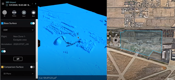
Esri SiteScan oblique photogrammetric and 3D earthworks imagery.
Once your CAD/BIM and GIS data is connected via the Civil 3D/Infraworks Connector for ArcGIS, your firm can ensure engineering, design, field survey and other work teams all use and rely on the same authoritative data. This reduces errors, boost overall productivity, saves time and money. ArcGIS Field Applications such as Collector in combination with Survey 123 allow teams to collect various forms of information such as asset location and related data with a high degree of accuracy. This information can be transmitted* back to the office in real time – to be immediately read in ArcGIS and Civil 3D. (* Transmission depends on connectivity. In remote locations, collected data will be stored and synced once connection is re-established.)
Data collection can be facilitated with a reasonable degree of accuracy for many projects by using an iOS or Android device. Precision can be enhanced to a survey degree of accuracy when using a GNSS device or other survey instruments. This allows firms to modernize field data collection for quick, correct, single source of authority data registration.
Here is a quick overview of the complete suite of ArcGIS Field Operations Applications.
Complex projects require a strong and engaging matrix of communications. Civil firms need to collaborate closely with their clients on projects, in addition to contractors, consultants, regulatory agencies, and the public at large. We all know projects are full of pitfalls, questions, changes, and a host of other factors. Clear and easily accessible communication from a central port of authority alleviate many breakdowns causing project disruption and delays.
The connection between Autodesk’s engineering technologies and Esri’s ArcGIS opens the door to a host of engaging communication tools which can be accessed by the entire project stakeholder chain with ease. ArcGIS online offers project viewing at no cost through the basic viewer. Using tools such as ArcGIS web scenes – create compelling real-world visuals of project CAD/BIM and GIS in an easy to understand format.
The addition of ArcGIS AEC Viewer User Type package allows individuals to mark-up and comment on the project. The ArcGIS AEC Viewer package also includes the ArcGIS Essential Apps Bundle – giving the Viewer User Type the ability to create project dashboards, web apps, story maps and perform other informative tasks.
If the project requires a private collaboration portal, the ArcGIS Project Delivery package is available. Project Delivery is an excellent repository for data as the project progresses and offers firms a secure method of working with clients during design and construction – it also creates an excellent hand-off package.
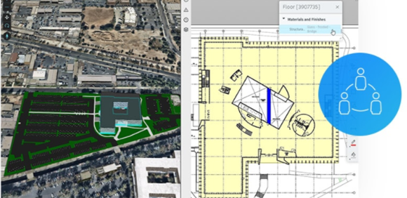
ArcGIS AEC Project Delivery Connected to Autodesk BIM 360.
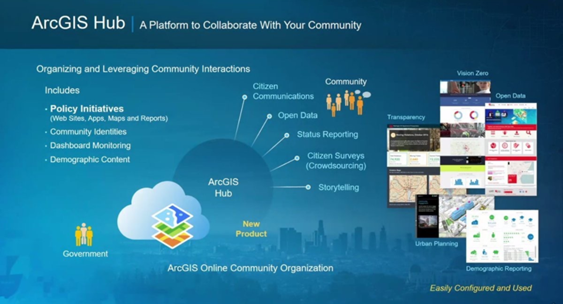
ArcGIS Hub can be incorporated in any of the project communication tools above to give and receive project feedback and discussion, organize project related meetings and layout much fuller project background and intent. ArcGIS Hub and any of the other ArcGIS tools can be enhanced with Esri’s Story Maps for informative and robust content to present the project in an robust yet visually appealing format.
These are just five of the many effective ways to create a fully informed engineering, design, and construction CAD-to-GIS program. MG AEC Technology Partners works with Civil Engineering and Construction firms across the United States to optimize project development workflows and processes. Our technical team has years of industry experience implementing and optimizing AECO workflows. If you would like to explore incorporating a robust CAD or BIM to GIS program in you firm’s workflow, please contact your MG representative or Eric Shaffer, Eric.Shaffer@mg-aec.com, New Business Development.

Stan Hennigh is MG’s Esri Partnership Manager as well as Business Development Manager for Esri, Scanning and Specialized Services. Stan’s recent project work has centered around BIM-to-GIS projects, smart FM projects. Sustainability, Reality Capture and Autodesk Forge development as it relates to BIM-to-GIS strategies.

